How Digital Elevation Models Are Transforming Geospatial Technology
How Digital Elevation Models Are Transforming Geospatial Technology
Imagine a city planner trying to prevent flooding in a low-lying area. They use advanced tools to analyze the land’s elevation, predict water flow, and plan drainage systems.
One key tool makes this possible: the digital elevation model (DEM). It’s a powerful resource shaping industries like urban planning, environmental management, and transportation.
A study shows that global mapping projects rely on DEMs for accurate terrain data. Whether you’re mapping flood zones or constructing skyscrapers, DEMs ensure precision.
So, how exactly are they revolutionising geospatial technology? Let’s find out.
What is a Digital Elevation Model?
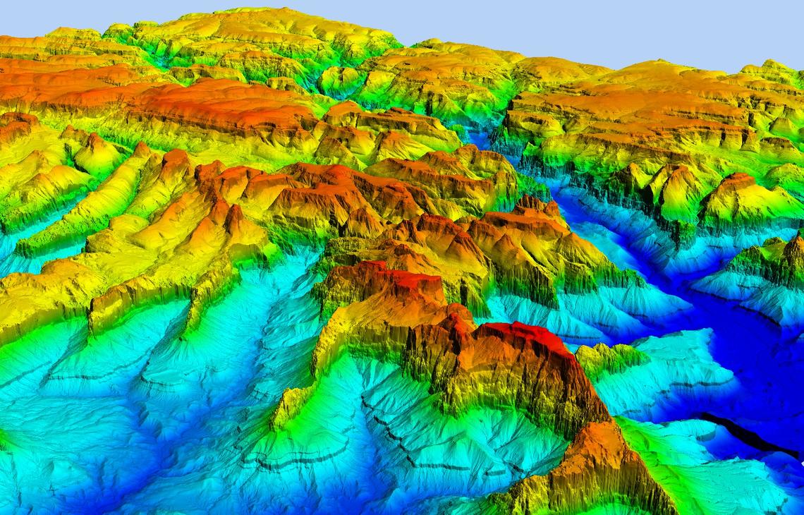
A digital elevation model represents the Earth’s surface in 3D. It is a virtual replica of the terrain, showing mountains, valleys, and plains. It’s created using technologies like LiDAR, photogrammetry, or radar.
Here’s a quick example. Suppose you’re planning a hiking trail. A DEM can highlight steep sections, water crossings, or areas prone to erosion. By using this data, you create safer, more enjoyable paths. But how does it work?
DEM data is typically presented in grid form. Each cell in the grid represents elevation. For instance:
| Grid Cell | Elevation (meters) |
| A1 | 500 |
| A2 | 480 |
| B1 | 520 |
| B2 | 495 |
| B3 | 470 |
This simplicity makes DEMs accessible across industries.
The elevation data provided above is hypothetical. For accurate elevation data, consult reliable Digital Elevation Models (DEMs) or geographic databases.
Why Are Digital Elevation Models Essential?
Let’s explore the practical uses of DEMs. Knowing the land’s elevation is critical if you’re a civil engineer designing a highway. Without it, you risk errors in slope grading, causing safety concerns or delays.
Here’s why DEMs matter:
- Urban Planning: Identify flood-prone areas to design resilient cities.
- Agriculture: Optimize irrigation by understanding terrain slopes.
- Disaster Management: Predict landslides and manage evacuation routes.
- Renewable Energy: Analyze terrain for wind farm placement.
- Transportation: Plan efficient routes, reducing fuel consumption.
For example, during dam construction, engineers used DEMs to map the river basin. This helped them locate the best spot for maximum water storage and minimal environmental disruption.
How Digital Elevation Models Work in Modern Geospatial Technology
DEMs integrate seamlessly with tools like Geographic Information Systems (GIS). GIS overlays vegetation or weather data on top of elevation models. This gives you a complete picture.
Let’s say you’re studying deforestation. A DEM combined with satellite imagery helps identify tree loss in hilly terrains. Similarly, city planners use DEMs with traffic data to optimize road networks.
Another exciting application? 3D visualization. Modern software converts DEMs into lifelike models. You can simulate floodwaters or visualize city skylines before construction begins.
Types of Digital Elevation Models: A Quick Comparison
DEMs come in two main types. Each serves specific needs:
| Type | Description | Use Case |
| Digital Terrain Model (DTM) | Represents bare earth, excluding trees/buildings | Flood mapping |
| Digital Surface Model (DSM) | Includes trees, buildings, and objects | Urban planning and skylines |
For instance, architects use DSMs to design buildings that fit naturally into a cityscape, while ecologists use DTMs for habitat studies.
DEMs in Action: Examples Across Industries
Here’s how DEMs are changing the game:
- Flood Management: Cities like Venice use DEMs to predict and manage rising tides.
- Transportation: Highways in mountainous regions rely on DEMs for safe construction.
- Tourism: Ski resorts use DEMs to design slopes that balance difficulty and safety.
Now imagine combining DEMs with drone technology. A farmer maps their field with a drone and DEM. This helps identify low spots where water collects, preventing crop damage.
Benefits of Using Digital Elevation Models
The advantages of DEMs extend far beyond terrain mapping. Here’s what makes them indispensable:
- Accuracy: High-resolution DEMs provide precise data, minimizing errors.
- Versatility: Use them in industries ranging from mining to real estate.
- Cost-Effective: Modern tools make DEMs more affordable than traditional surveys.
- Scalability: Suitable for projects of all sizes, from small farms to national infrastructure.
- Predictive Power: DEMs help foresee problems like erosion or flooding.
For example, a study on coastal erosion used DEMs to predict shoreline changes over 20 years. This guided policy decisions on protective measures.
The Future of Digital Elevation Models in Geospatial Tech
The future is bright for DEMs. Emerging technologies like AI and machine learning are boosting their capabilities. AI algorithms can process DEM data faster and with greater accuracy. This unlocks real-time applications like monitoring landslides or tracking urban growth.
Imagine this: Smart cities using DEMs for underground utility planning. Or autonomous vehicles navigating terrains with precision thanks to DEMs.
By 2030, experts predict DEMs will play a vital role in digital twins—virtual replicas of physical environments used for planning and monitoring.
How Digital Elevation Models Enhance Climate Change Research
Climate scientists rely heavily on digital elevation models to predict and analyze environmental changes. DEMs help track glacial melt, map flood risks, and monitor rising sea levels.
For example, researchers used a DEM to model the impact of a 2-meter rise in sea level on coastal cities. This data informed decisions on building seawalls and relocating vulnerable communities. DEMs make such predictions actionable, aiding in sustainable planning.
How Accurate Are Digital Elevation Models? Breaking Down the Factors
Accuracy in a digital elevation model depends on several elements:
- Resolution: Higher resolution captures finer details.
- Technology Used: LiDAR offers unmatched precision.
- Terrain Complexity: Flat areas are easier to model than dense forests.
- Data Processing: Advanced algorithms reduce errors.
For instance, while a LiDAR-based DEM may offer a 5-meter resolution, satellite-based models might only reach 30 meters. Choosing the right DEM depends on the project’s needs.
Digital Elevation Models in Disaster Preparedness: A Game Changer
Disasters like floods and landslides demand proactive measures. A digital elevation model equips governments and agencies with terrain-specific insights.
Here’s how DEMs aid disaster preparedness:
- Map evacuation routes in flood-prone zones.
- Identify areas vulnerable to landslides.
- Plan post-disaster recovery using terrain data.
For example, a DEM helped predict flood zones during Hurricane Katrina, allowing for faster evacuation and relief deployment. This proactive use of DEMs saves lives and resources.
Final Thoughts
Digital elevation models are transforming industries by offering unparalleled terrain insights. Whether preventing floods or planning infrastructure, DEMs have become essential.
Curious how DEMs can enhance your projects? Satpalda Geospatial Services offers geospatial solutions tailored to your needs.
FAQs
1. What is the purpose of a digital elevation model?
To represent terrain in 3D for analysis and planning.
2. How are digital elevation models created?
Using technologies like LiDAR, photogrammetry, and satellite imaging.
3. What industries use digital elevation models?
Urban planning, agriculture, transportation, disaster management, and renewable energy.
4. Can DEMs predict natural disasters?
Yes, they help forecast floods, landslides, and erosion by analyzing terrain data.


